There are lane reversals for rush hour traffic routing into and out of Panama City on Monday through Friday as such you will need to use the Centenario Bridge. (Route 4) Click here for a Google Maps with directions from the Centenario Bridge
ATTENTION: Due low lake levels we are now picking up clients at the Escondida Restaurant here in Arenosa. http://tinyurl.com/bdfvxk86
Transporation
If you are using WAZE, here is a link to Arenosa https://waze.com/ul/hd1x5kwp1x
Listed below, in no particular order, are several bilingual taxi/van drivers or transportation services' and their contact information. All of these have brought people out to Arenosa to fish with us. All of them also offer airport pickup services. You will need to contact them directly to make your arrangements. (If you are calling from outside Panama you will need to add 011-507 to the front of their telephone numbers.)
Luis Rodriguez 6259-5466 [email protected]
Karl & Wanda McKenzie https://wetourpanama.com/ +507 6538-2680
Gabino 6-513-6327 [email protected]
Maciste 6460-9342 [email protected]
Delano Prescott 6662-4880 ( [email protected] )
Blas González 6978-3185 , 6887-9137 ( [email protected] m )
Coronado/Decameron - Carlos Taxi 6930-2440
Servicios Koo & Asociados Aniel Falquez (+507) 6501-3037 /(+507)6673-8140
(www.servkooasociados.com)
David 6-894-8547
Javier 6-684-0846
Marcel 6-266-8397
Driving Directions to Arenosa
The roads all the way to Arenosa are paved and in good condition and it only takes a little over an hour to drive the 50 miles from Panama City. The first 30 miles (48KM) is on four lane divided highways and the last 20 miles (31KM) is on a two lane road.
Note: If you are heading East from the Pacific Beach areas and towards Panama City PLEASE CLICK HERE for alternative directions
Heading West out of Panama City on the InterAmerican Highway after you pass the Super Extra in Arraijan you pass over the AutoPista and will then bear to the left at the fork. (The signs reads Chorrera Autopista) Just stay on the Autopista until it ends and you will come into an area with several service stations and other businesses (You will see a McDonald's and a Puma Gasoline station and "Super 7" convenience store on your right. (They are open 24-7 and you can pick up ice, beer, soft drinks or snacks
you may have forgotten.) Shortly after you pass this area you will see a new Terpel service station on the right and the Back Packer Inn on the left. Shortly after that, start looking for some small signs that say Arenosa, Santa Rita and El Espino. You will see an elevated pedestrian crosswalk and a Delta Gas Station on the left. (The Delta Station sign actually says El Espino on it) Just as you pass under this crosswalk on the right directly across from the Delta Station is a Chino tienda and a two lane paved road. Coordinates: 8°50'16.13"N (8.837814°) 79°50'50.60"W (-79.847389°)
Turn right on this road and proceed 25 km. Note: A little over 2 km in there is a fork in the road but stay to the right. Just follow, on the paved road, all the way. If you look closely you will see small white concrete KM markers every now and then along the way.
The road to Arenosa is a country road that winds through some lovely rolling hill countryside with fincas, chickens, horses, cows and lots of pineapple farms. The biggest traffic problems are the "chivas" stopping every mile or so to pick up people and of course dogs, chickens, tractors and even cows in the road. Take your time and enjoy the scenery.
Just before the 25 KM there is a sign indicating Arenosa is to the left. You will turn left directly in front of the 25 KM marker. Coordinates: 9° 1'25.82"N ( 9.023839°) 79°54'24.57"W (-79.906824°) Once you turn left,(the KM markers continue to go up) and when you have driven six more KM you will see the 31 KM marker just as you are entering the village of Arenosa.
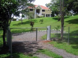
Immediately after the 31 KM marker you will see my house and driveway entrance on the right. The driveway entrance and my house are light olive green with white trim and the house is on columns. Just beyond the main driveway you will see another entrance with parking. Coordinates: 9° 2'31.56"N ( 9.042101°) 79°56'54.91"W (-79.948587°)To get to the pontoon boat you will be turning in this second driveway. This entrance and parking area are crushed rock and only about 150 feet past the marker (See the picture below) If someone is not there to meet you, honk the horn and the guide and/or I, will come up and help you carry anything you need to take to the boat.
Email: [email protected]
Telephone : 011-507-6-267-3339 Voice or WhatsApp
Click on Me to Go to the Home Page