Depending on how far West of Panama City you are the first few miles could vary so these directions start in the area of Decameron and Rio Hato. For Google Map directions from click here: Coronado Directions
After passing the entrance to Decameron you will go through a few smaller towns, Santa Clara and San Carlos are the ones I recall. I do not recall exactly how far it is from there to Coronado but when you see a McDonalds and the El Rey and Super99 Supermarkets you are at Coronado. This might be a good place to pick up drinks and snacks. After Coronado you will pass some more small towns including Chame, Bejuco and then you will come up over a mountain (Altos de Campana) and then the town of Capira. After you pass through Capira you will drive about 5 to 6 minutes or so and on the right, you will see a Delta Gas Station. There is actually a small sign on the highway telling you that the Delta Station is just ahead and from there you can see the sign at the Delta Station on the top of the next hill. (This sign actually says Estation El Espino on it) You can also see a elevated pedestrian crosswalk in front of this gas station. Once you see this Delta station get in the left hand lane. There is actually a left turn lane as you approach the intersection. Get into it. Directly across from the Delta Station (on he left) is a Chino tienda and a two lane paved road beside it. Turn left onto this road and proceed 25 km. Coordinates: 8°50'16.13"N (8.837814°) 79°50'50.60"W (-79.847389°) After turning left off the InterAmerican Highway onto this road proceed 25 km. Just stay straight on the paved road all the way. Note: A little over two kilometers in on this road you will come to a fork in the road. Stay to the right. You will see small white concrete KM markers along the way.
The road to Arenosa is a country road that winds through some lovely rolling hill countryside with fincas, chickens, horses, cows and lots of pineapple farms. The biggest traffic problems are the "chivas" stopping every mile or so to pick up people and of course dogs, chickens, tractors and even cows in the road. Take your time and enjoy the scenery.
Just before the 25 KM there is a sign indicating Arenosa is to the left. You will turn left directly in front of the 25 KM marker. Coordinates: 9° 1'25.86"N (9.023804°) 79°54'24.18"W (-79.906714°)Once you turn left,(the KM markers continue to go up) and when you have driven six more KM you will see the 31 KM marker just as you are entering the village of Arenosa.
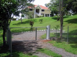
Immediately after the 31 KM marker you will see my house and driveway entrance on the right. The driveway entrance and my house are light olive green with white trim and the house is on columns. Just beyond the main driveway you will see another entrance with parking. Coordinates: 9° 2'31.56"N ( 9.042101°) 79°56'54.91"W (-79.948587°) To get to the pontoon boat you will be turning in this second driveway. This entrance and parking area are crushed rock and only about 150 feet past the marker (See the picture below) If someone is not there to meet you, honk the horn and the guide and/or I, will come up and help you carry anything you need to take to the boat.
For more information contact: Dennis Melton
Email: [email protected]
Telephone : 011-507-6-267-3339 Voice or WhatsApp
Click on Me to Go to the Home Page